

![]() Access
Access
![]() Weather
Weather
![]() Maps
Maps
![]() Guide
Books
Guide
Books
![]() Clothing
Clothing
![]() Potential
natural hazards
Potential
natural hazards
![]() Terminology
Terminology
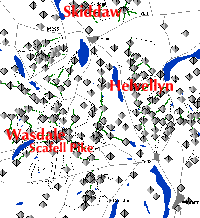
Characterised by easy to moderate ridge walking on usually well cairned (US ducks) paths. The most popular areas will be very busy in summer. The hills in the south of the area are rockier in nature particularly around Wasdale. Here you will find England's highest peak Scafell Pike, which with Helvellyn and Skiddaw, forms the three most popular summits. Striding Edge on Helvellyn attracts thousands of visitors each year to its narrow ridge scramble. All summits can be tackled as day walks and many circular walks can be devised. Accommodation is plentiful and roads penetrate into all areas.
Related pages:-
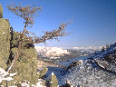
The Lake district in photos
Wasdale
Wainwright's Guides the long established authoritative books for lakeland walkers
Somewhere special to eat out in the ELD: L'Enclume
Snowdonia(North Wales)
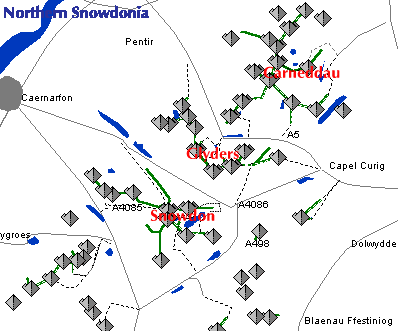
Welsh speaking (bilingual with English) Snowdonia has at its centre Snowdon (Yr Wyddfa). Although a steam driven cog railway runs to the top in summer there are many fine routes to its summit. The finest of all being the Snowdon Horseshoe, ascending the mountain along a knife edge ridge of some difficulty for the average walker. Other Snowdon routes are without special difficulty. Other popular ranges are the Glyders (especially Tryfan) to the East of Snowdon, and further still to the East the Carneddeau.. Other hills are quiet and relatively unfrequented. The hills of Snowdonia are generally rockier and rougher than the Lake District, slightly higher, and as a consequence a little more difficult in the ascent.
Related pages:-
Snowdonia photos
Guide books
Nantlle Ridge
Wilder landscape with sometimes long walk-ins to remoter mountains.Do not be deceived by low altitudes compared with mainland Europe. Less habitations than elsewhere. Wild camping often appropriate. Many hills are pathless and the excessive use of cairns (US ducks) to mark paths is discouraged. Be ready to navigate by map and compass alone on all but the more popular mountains.
By far the largest area of mountains in Britain, the highlands can be very roughly divided into four areas.
Western
Mountainous right down to the deeply indented coast. Hill ranges divided by both fresh and salt water lochs.
Eastern
High plateaux, most notably the Cairngorm range.
Northern
Wet low moorland with isolated, often impressive mountains.
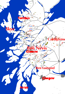
Isle of Skye, Hebrides and Northern Isles (Orkney and Shetland)
The Black Cuillin on Skye are probably in a class of their own in the British mountains requiring moderate rock climbing skills in many places. Being further North, summer days are very long. Winter days are of course correspondingly short, night falling as early as 16.00. In July-August biting midges can be a problem in calm, warm conditions near water at low altitude. Skye also offers opportunities for easier walks such as the Trotternish ridge and the Scottish islands are in general fascinating to explore.
Related pages:-
Scottish highlands photos.
Scottish Islands photos
Guide books - Highlands
Guide books - Islands
Aonach Eagach the easy way
Terminology to get right. (some obvious, some not - even to Brits!)
Scots and scotch. The Scots or Scottish people inhabit part of "(Great) Britain" and the "United Kingdom (UK)", in a union with England, Wales & Northern Ireland.
"Scotch" refers only to whisky, beef, smoked salmon and mist.
Orkney and Shetland have "mainlands" and named islands, they are never referred to as "the Shetlands". That would be the same as saying "the Britains". You can say "the Shetland Isles" as you can say "the British Isles".
England
does not include Scotland or Wales.
The British
Isles includes Ireland but "Britain" or the "UK" do not.
Northern
Ireland is the east part of Ulster in the north of Ireland, its inclusion
in the UK is a vexed matter in Ireland, although power sharing arrangements
are currently in place and there is now (2004) no serious violence in Northern
Ireland. If the subject comes up in an Irish pub my advice is to listen
politely, or maybe ask questions, rather than voicing opinions which may
not reflect the full facts (or the local perception of them) until the
subject changes.
Access
Keep to indicated footpaths through enclosed fields. Access to mountain ridges generally unrestricted in England and Wales. Sheep farming is usual economy in England and Wales but is replaced, in the Highlands, by deer and game birds kept for paying guests to hunt , along with forestry. This results in access restrictions during the hunting season. Some hills are however in the ownership of the National Trust for Scotland and can be accessed at any time.
Red deer
stalking 1st July- 20th October. (often starts later)
Red deer
culling 21st October - 15th February.(often finishes earlier)
Grouse
shooting 12th August - 10th December.
No stalking
takes place on Sundays.
This does
not mean that no access is allowed during these periods but that prior
enquiry should be made before walking.
"Heading
for the Scottish Hills" Scottish Mountaineering Trust gives telephone
numbers and full details. Essential reading.
The
bagpipes and the gentleman
A definition
of a 'gentleman': A person who knows how to play the bagpipes, but abstains
from practicing.
with thanks
to Ronald
Hillphones
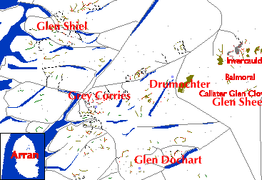
Recorded
information on stalking for walkers 1st August - 31st October
Grey Corries/Mamores
01855 831 511
Glen Dochart/Glen
Lochay 01567 820 886
North
Arran Hills 01770 302 363
South
Glen Sheil 01599 511 425
Drumochter
01528 522 200
Glen Shee
01250 885 288
New for
1999:-
Callater
and Clunie 013397 41997
Invercauld
013397 41911
Balmoral/Lochnagar
013397 55532
Glen Clova
01575 550335
The Irish hills do not follow the general pattern of Britain, where higher peaks are found as you go north. By contrast Ireland's highest hill is in the far south in Kerry, Carrauntuohill, part of MacGillycuddys Reeks, along with the second highest Brandon Mountain.
All British weather is very changeable, the mountain areas more so (parts of Scandanavia and southern South America such as Iceland and Patagonia are the only places in the world where the weather can compete with the UK for unpredictability).The UK does not however suffer from any extreme weather. Walkers must always be equipped for rain (60 inches precipitation per annum or more) and wind. South and West winds bring mild maritime conditions with rain. North and east winds bring colder drier conditions.
Snow is most likely between October and May, when ice axe and crampons may be needed, but cannot be relied on to be present at any time. Equally on the highest summits small amounts may fall in any month of the year. Eastern hills always hold more snow than Westerly, this being particularly noticeable in Scotland where coastal hills such as the Cuillin are unreliable for snow. Altitude obviously also plays its part, the higher hills holding more snow. Winter storms on the Cairngorm plateau are notorious for their ferocity, complicated by the topography and short days.
Related pages:-
Temperature Inversions.
Weather books
Links:-
Forecasts
Ordnance Survey and other maps (Harveys) are easily available at booksellers and specialist shops and are of good quality.
Most walkers use 1:25000 ("2 inches to mile", yellow cover) in the Lake District and Snowdonia and 1:50000 ("1 inch to mile", red cover) in Scotland.
Note that on the 1:25000 series legal "rights of way" are marked by green dashes, while actual paths on the ground are marked by small black dashes.
Harvey's are specialist walkers maps and substitute detail more useful to walkers for some general information.
Guide
books
The
High Mountains of Britain and Ireland Butterfield Diadem Vol 121x25cm
320p colour
If visiting
from outside UK and Ireland this is probably the best guide for the Scottish
hills and major other hills available internationally.
The 3000ft.
mountains (including tops) of British Isles. Also available in pocket size
version.The 3000ft. limit obviously excludes most of the English Lake District
but Ireland is a bonus. Usefully describes the general characteristics
of each area at beginning of each chapter. Often gives more than one route
to the hills. Access information and many good photographs. If your only
interest is the Munros, tops and 'furths' this could be your sole guide
book.The "volume 1" in the title of recent copies relates to an abandoned
plan to cover the lower hills in a second volume.
![]()
![]()
More
walking books
Language
Visitors
cannot rely on any other language but English being spoken, except where
bilingual with Welsh in North Wales and Gaelic in Ireland and the remoter
islands of Scotland. Expect marked difference in pronunciation from "BBC"
or American English in all mountain areas.
Clothing
The layer
system.
British
weather is vary variable and requires a flexible approach. Breathable thermal
underwear, a fleece jacket and a wind and waterproof shell jacket and overtrousers
suit most walkers. Insulated outer jackets are generally too warm for much
of UK windy/wet weather. Wet ground is frequent so reasonably waterproof
boots are required.
Natural
hazards
Britain
is generally free from dangerous wildlife but the following merit consideration
(in a lifetime of walking none of these things have happened to me or anyone
I know) :-
Adder
Our one
poisonous snake, you will be lucky to see one and very unlucky to be bitten.
If you are remain calm to stop poison rushing through your bloodstream
and contact emergency services by phoning 999.
Sheep
Tick
In upland
areas can become attached to walkers legs. If red tracking develops afterwards
contact a doctor as there is a risk of contracting Lyme disease
Farm stock
Certain
types of bull are allowed in fields with footpaths but only when with cows.
Should cattle become over curious frighten them away by shouting and waving
arms or better still waving a stick.
Nettles
A minor
hazard of lowland footpaths is the stinging nettle, not serious but the
stings are uncomfotable. In summer consider having access to long trousers
on lowland walks.
Wasps
and Bees
Both can
sting. The bee (essential to our ecology) will not bother you and stings
only as a final defence and then dies.
However,
the wasp, particularly from August until October, makes a nuisance of itself
by being attracted to sweet things like your picnic or pint of beer. The
sting is not serious unless allergic, except in the case of accidentally
swallowing one.
| A footnote on food and drink for visitors | ||||
 |
The British
pub is often the preferred place to eat and relax after a day in the hills.
Nearly all now serve food but still usually close at 11.00pm except in
Scotland. Food orders may stop much earlier (possibly 9.00pm). Pubs in
mountain locations popular with walkers include:-
Clachaig Inn in Glencoe. Cluanie Inn between the South Cluanie ridge and Five Sisters. The Wasdale Head in Wasdale, Lake District. The Woolpack in Eskdale, Lake District. The Newfield Inn, Seathwaite, Lake District. The Old Dungeon Ghyll in Langdale, Lake District. The Pen-y-Gwryd near Snowdon and the Tyn-y-Coed & Bryn Tyrch near Capel Curig in Snowdonia. The Climbers Inn, Glencar, Kerry. All the above have accomodation and most have campsites nearby. Drink-driving limit in UK 80mgs (1999) which is an absolute maximum of two pints of normal strength beer for a man of about 6 feet in height and drunk over a period. |
|||
| For
more information on British
beer refer to official CAMRA site. |
||||
|
Order British beer ( called "bitter", "ale" or "real ale", to distinguish it from "lager") from hand pumps on bar top by pint or half-pint glass which acts as measure, therefore glass is full to top (unless the pub is using "lined" glasses). British beer is served at cellar temperature (cool not cold, as suited to the climate and the type of beer) and should not be factory filtered or have added gas to make it fizzy or be served by gas pressure ("keg" beer). In Ireland the tradition is different and keg extra stout porter (now abbreviated to "stout") is almost universal, "Guinness" being the most well known brand. Expect to wait five minutes while the drink settles before being topped up. Almost every pub in Ireland serves "the best pint of Guiness in Ireland", in truth this is a concept more in the mind of the drinker than reality. More on pubs |
||||