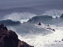

Kynance Cove storm

Penberth

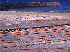
Cadgwith cat
Sennen

 At
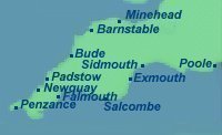
613 miles the South West Penninsula Way is the longest of the National
Trails. Most tackle it in sections breaking off at a major town where transport
is available. A continuous walk will take seven or more weeks. The South
West Way Association recommend:- Week 1 Minehead-Westward Ho!(Nr. Barnstable)
Week 2 on to Newquay. Week 3 on to Penzance. Week 4 on to Mevagissey (25
miles east of Falmouth). Week 5 on to Salcombe. Week 6 on to Sidmouth.
Week 7 on to Poole.
At
613 miles the South West Penninsula Way is the longest of the National
Trails. Most tackle it in sections breaking off at a major town where transport
is available. A continuous walk will take seven or more weeks. The South
West Way Association recommend:- Week 1 Minehead-Westward Ho!(Nr. Barnstable)
Week 2 on to Newquay. Week 3 on to Penzance. Week 4 on to Mevagissey (25
miles east of Falmouth). Week 5 on to Salcombe. Week 6 on to Sidmouth.
Week 7 on to Poole.
The walk comprises seaside towns, fishing ports, picturesque coves, cliffs and beaches. The many ups and downs between cliff top and beach make it a harder walk that might be expected.
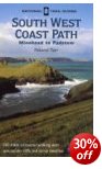
Guide books
The first step in planning the walk is to obtain a copy of "The South West Coast Path"by the South West Way Associationfrom the membership Secretary:-
Sarah Vincent, 25 Clobells, South Brent, Devon TQ10 9JW Phone/Fax 01364 73859. email £4.99 (1999) (200g) which tells you just about everything you could want to know about all aspects of walking the path. Or join the association and receive the book free each year.
Also the appropriate OS sheets
1:50000 (12 sheets)180, 181, 190, 192, 193, 194, 195, 200, 201, 202, 203, 204,
or 1:25000 (17 sheets) OL 9, 15 and 20. Explorer 102, 103, 104, 105, 106, 107, 108, 109(fragment only), 110, 111, 115, 116, 126, 139.
(an OS map weights about 100g.)
An alternative is to use the OS National Trail Guides in four volumes.
These weigh
250g each but include appropriate OS map extracts at 1:25000, however this
could be insufficient if a detour inland is required.
 Minehead-Padstow
 ![]()
![]()
Padstow-Falmouth ![]()
![]()
Falmouth-Exmouth ![]()
![]()
Exmouth - Poole ![]()
![]()
See also:-
Cicerone SW
Coast path ![]()
| North to south from Minehead-structured for even pace for a continuous walk. | ||||||
| Week | Finish at | Weekly | Aggregate | |||
| 1 | Westward Ho! | 86 | 86 | |||
| 2 | Porthcothon | 88 | 174 | |||
| 3 | Penzance | 90 | 264 | |||
| 4 | Mevagissey | 85 | 349 | |||
| 5 | Salcombe | 91 | 440 | |||
| 6 | Sidmouth | 85 | 525 | |||
| 7 | Sandbanks | 88 | 613 | |||
See also:-
Long Distance footpaths