Y Garn 2080
Drws-y-Coed 2286
Trum y Ddysgl 2329
Tal-y-Mignedd 2148
Craig Cwm Silyn 2408
Garnedd-Goch 2301
(Could
be extended to Graig Goch 1999)
There are
a number of options to consider when planning a traverse of the ridge ("Nantlle
ridge" is possibly a misnomer, the walk is better described as a series
of "edges" above Cwm Pennant, perhaps "The Pennant aretes" would have been
a better name?). It is necessary to decide whether you wish to "bag" all
the summits or wish to follow the most interesting rock scenery.
Perhaps the line of the watershed appeals, continuing on to Graig Goch?
The Pennant Horseshoe
Described
in "Classic Walks", ![]() a
long horseshoe around Moel Hebog and the Nantlle ridge starting from Pont
Gyfyng. Somewhat contrived as the route descends to valley level half way.
a
long horseshoe around Moel Hebog and the Nantlle ridge starting from Pont
Gyfyng. Somewhat contrived as the route descends to valley level half way.
Nantlle 2000s
Drws-y-coed
to Garnedd-Goch taking in all the 2000 foot peaks.
The Watershed
Drwys-y-coed
to Graig Goch.
The Classic Ridge
Drws-y-coed
to Craig Cwm Silyn descending north to Nantlle along the rim of Craig Cwm
Silyn.
Apart
from the strenuous horseshoe these walks must all be at least partly reversed
unless a second car can be left in the Nantlle area.
What the guide books say:-
"The
High Summits of Wales" Uney (Guide to the Welsh "Hewitts")![]()
"this
ridge is possibly one of the finest high level walk in Wales"
"Beyond
Craig Cwm Silyn another minor top can be included in the walk,
although
if returning to Rhyd Ddu its not really worth it"
"Great
British Ridge Walks" Birkett![]()
"Rightly
regarded as one of the great ridge walks of Snowdonia".
Description
unusually west to east. Described as "moderate difficulty and unstrenuous"...depends
on the individual I suppose.
"The
Ridges of Snowdonia" Ashton![]()
Talks
of "gentle" "forgotten" and "short infrequent scrambles". This does not
describe
the
route for me. Although it has six pages of description, much of it is oblique
in nature.
Describes
Y Garn to Garnedd Goch then north to Nantlle
The
Mountain of England & Wales Volume 1 Nutall (Welsh
hills of 2000 feet)![]()
"This
long airy ridge is one of the finest high level ridge walks in Wales"
"The
Welsh Peaks" Poucher (second-hand only)
"a
prize for the connoisseur". Poucher recommends following the rim of the
cliffs of Craig Cwm Silyn down towards Nantlle, with Garnedd Goch summit
cairn as an optional extra.
(![]() click
on price button to go to Amazon.co.uk)
click
on price button to go to Amazon.co.uk)
After crossing
a field on a slate path start to climb up across a second field following
white painted arrows. Soon the path steepens and climbs up to the start
of the ridge proper at the summit of Y Garn which is reached after an area
of stones and a stile over a wall. ![]() Turning
west the ridge rapidly narrows and exposed situations occur as crags and
boulders narrow the choices of route available. Just before the summit
of
Turning
west the ridge rapidly narrows and exposed situations occur as crags and
boulders narrow the choices of route available. Just before the summit
of![]() Drws-y-Coedan
awkward step appears. Keeping to the crest requires a big step across a
gap, while the bypass route is on an exposed ledge. Probably the safest
option is to stay on the crest up to the step and then slide down to the
end of the bypass path. A few yards on and all difficulties disappear and
the route reverts to grass and on to the featureless summit of Drws-y-Coed.
Cliffs continue on the right (N) side to Trum y Ddysgl with its strange
flat grass summit. A descent path is available (leaving SW onward route
S near summit) here returning through the forestry to rejoin the outward
route. After the col scramble up to Craig Cwm Silyn. A second descent path
starts here but does involve renascent to join descent route 1. Or
descend north along the rim of Craig Cwm Silyn towards Nantlle or carry
on along the watershed. The latter options will require a second car parked
in the Nantlle area.
Drws-y-Coedan
awkward step appears. Keeping to the crest requires a big step across a
gap, while the bypass route is on an exposed ledge. Probably the safest
option is to stay on the crest up to the step and then slide down to the
end of the bypass path. A few yards on and all difficulties disappear and
the route reverts to grass and on to the featureless summit of Drws-y-Coed.
Cliffs continue on the right (N) side to Trum y Ddysgl with its strange
flat grass summit. A descent path is available (leaving SW onward route
S near summit) here returning through the forestry to rejoin the outward
route. After the col scramble up to Craig Cwm Silyn. A second descent path
starts here but does involve renascent to join descent route 1. Or
descend north along the rim of Craig Cwm Silyn towards Nantlle or carry
on along the watershed. The latter options will require a second car parked
in the Nantlle area.
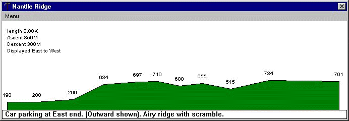
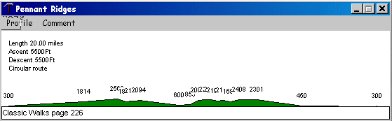
profile of the watershed as far as Garnedd-Goch
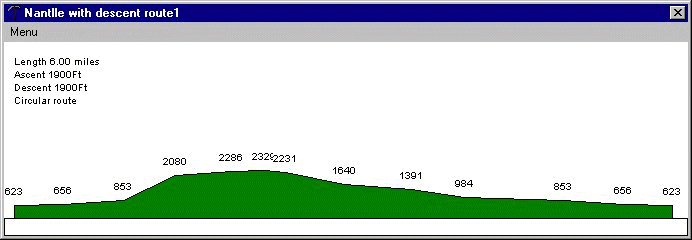
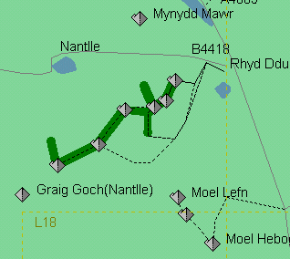
A circular walk descending off the SE of the ridge.
Sign guestbook