If you don't enjoy scrambling there is no need to undertake the difficulties of the Aonach Eagach on the north side of Glencoe to reach the summits of its two Munros.
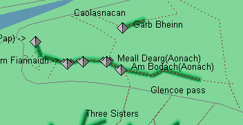
A good path ascends from Caolasnacan (parking for a few cars) at first following the north side of the river and then heading directly for the col between Garb Bheinn and Meal Dearg's north spur. From the col turn right (S) following the ruined fence to the summit (good views of the "notched ridge" above-right
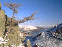
Sgoor nam Fiannaiddh
(approx. 950m in 3.0K, 3100ft in 2 miles)
Avoid
the steep path from the Clachaig inn and instead walk along the old road
for just under 2 miles and take the "Pap" path (turn right off the made
up track well before it zigzags), then branch off right (E) again near
the start of the prominent ravine of the Allt a'Mhuilinn. An obvious path
zigzags to the summit joining the Clachaig path near a prominent cairn.
Sgoor
na Ciche (Pap) may be included by going to its summit by the usual route
and then retracing steps to the col and then following discontinuous faint
tracks (SE) over rough ground to Sgoor nam Fiannaiddh with its amusing
wind shelter containing a trig point.
The ridge
then narrows and continues on to the top of Stob Coire Leith.
In descent take care not to pick up the direct descent to Glencoe and to not stray south off the path into stone shoots.If in doubt keep right (NW).