These are fairly easy, usually short walks (that could often be extended). The end is not an end, enjoy what you can find along the way.
 1.Herma
Ness
1.Herma
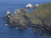
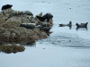
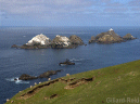
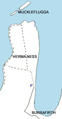
Ness Muckle Flugga forms the northern tip of the British Isles. While it might be worth visiting for that alone its western coast is splendid. The route is duck boarded where necessary across the nature reserve (keep to paths, partly to minimize bonxie attacks). Puffins breed on the west coast and will approach a walker who stays still and quiet. The gannetries are on the offshore stacks to the north. Great Skuas (Bonxies) breed on the moorland interior. The walk is unfenced with one gate to negotiate and one stretch of fairly steep ground on grass on the western side. It is recommended not to wear overtrousers near the sloping cliff edges due to lack of friction in a slip on wet grass. Parking is at the road end. Do not obstruct the bus turning or the sheep pens. Additional parking at the visitor centre below.
Herma Ness photos.
 This
is a "must do" walk. Save it for a clear day for both navigation and
views.
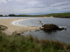
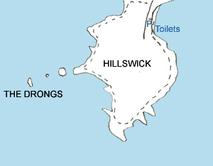
Park at the public toilets behind the beach in Hillswick and walk south
along the foreshore and then on grass, keeping to the coast. There are
one or two fences to be negotiated before the land starts to rise into
cliffs. Continue round the ness for impressive views of rock stacks
from
the undulating route. Cliffs appear before you unexpectedly and I
suspect
that in mist the unwary could conceivably step off one! At the end of
the
walk keep "left" of all farm walls until a small beach is on your left
and the cemetery is on your right, then strike inland to a gate
and
stile by the road.
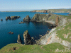
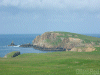
This
is a "must do" walk. Save it for a clear day for both navigation and
views.
Park at the public toilets behind the beach in Hillswick and walk south
along the foreshore and then on grass, keeping to the coast. There are
one or two fences to be negotiated before the land starts to rise into
cliffs. Continue round the ness for impressive views of rock stacks
from
the undulating route. Cliffs appear before you unexpectedly and I
suspect
that in mist the unwary could conceivably step off one! At the end of
the
walk keep "left" of all farm walls until a small beach is on your left
and the cemetery is on your right, then strike inland to a gate
and
stile by the road. Ness of Hillswick photos
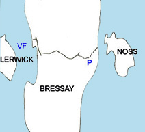 When
the reserve is open take the Bressay ferry from the centre of
Lerwick
and drive across Bressay, park and walk down to the channel between the
two islands. The warden will collect you by "zodiac" and take you to
the
visitor centre. From there you can walk round the edge of the island.
An
excellent boat trip <website>
is
also
available
to
view
the
cliffs from below.
When
the reserve is open take the Bressay ferry from the centre of
Lerwick
and drive across Bressay, park and walk down to the channel between the
two islands. The warden will collect you by "zodiac" and take you to
the
visitor centre. From there you can walk round the edge of the island.
An
excellent boat trip <website>
is
also
available
to
view
the
cliffs from below. Noss photos
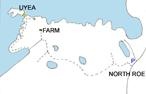 Uyea
is in the north of Northmavine, featuring the oldest rocks on Shetland,
the route to it uses a newly improved and gated farm track to cross the
boggy land around it. Look for red throated divers on the various
lochans.
The track starts next to a blue hut and descends for a few minutes past
past farm building, ignoring a track on the right the track climbs up
onto
the moorland. When the track eventually descends towards the farm/croft
at Uyea look for the line of an old wall going SW. (solid line on
sketch
map) Follow this to South Wick, thus avoiding the fences of the farm,
then
follow the coast round north to Uyea island. The island is linked to
the
mainland at low tide only by a beach.
Uyea
is in the north of Northmavine, featuring the oldest rocks on Shetland,
the route to it uses a newly improved and gated farm track to cross the
boggy land around it. Look for red throated divers on the various
lochans.
The track starts next to a blue hut and descends for a few minutes past
past farm building, ignoring a track on the right the track climbs up
onto
the moorland. When the track eventually descends towards the farm/croft
at Uyea look for the line of an old wall going SW. (solid line on
sketch
map) Follow this to South Wick, thus avoiding the fences of the farm,
then
follow the coast round north to Uyea island. The island is linked to
the
mainland at low tide only by a beach. Uyea photos
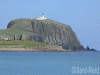
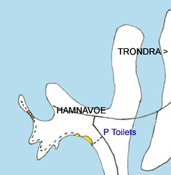 A
walk to the lighthouse. Park at the toilets and take the raised walkway
to the delightful beach, follow the coast NW using a mixture of smart
new
and old stiles to eventually reach the lighthouse across a boulder
field.
A
walk to the lighthouse. Park at the toilets and take the raised walkway
to the delightful beach, follow the coast NW using a mixture of smart
new
and old stiles to eventually reach the lighthouse across a boulder
field. Hamnavoe photos
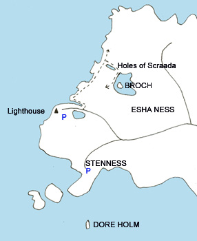 A
beautiful stretch of coast. Walk at
least as far as the Holes of
Scraada,
where a subterranean passage has caved in to form an inland cave and
beach.
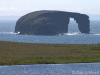
From Stenness walk south west and anti clockwise along the coast for
views
of Dore Holm.
A
beautiful stretch of coast. Walk at
least as far as the Holes of
Scraada,
where a subterranean passage has caved in to form an inland cave and
beach.
From Stenness walk south west and anti clockwise along the coast for
views
of Dore Holm. Eshaness photos
 Two
paths from a small parking area at the end of the road. The coast path
leads to the lighthouse. After passing through a gate by a house the
two
paths split and are signposted to the Hams and the lighthouse. Take the
left-hand path through a field gate and down to a beach with a cliff
beyond.
A path can be seen ahead leading up the edge of the cliff, ignore it!
Half
way across the beach where a stream flows into the sea, strike inland
at
45 degrees to the coast to pick up the true path which runs behind the
cliff and, after a stile, is protected by a handrail on an exposed
section.
At a lochan don't miss a sharp turn to the left, ignoring a path going
ahead by the lochan side. The small lighthouse is then ahead.
Two
paths from a small parking area at the end of the road. The coast path
leads to the lighthouse. After passing through a gate by a house the
two
paths split and are signposted to the Hams and the lighthouse. Take the
left-hand path through a field gate and down to a beach with a cliff
beyond.
A path can be seen ahead leading up the edge of the cliff, ignore it!
Half
way across the beach where a stream flows into the sea, strike inland
at
45 degrees to the coast to pick up the true path which runs behind the
cliff and, after a stile, is protected by a handrail on an exposed
section.
At a lochan don't miss a sharp turn to the left, ignoring a path going
ahead by the lochan side. The small lighthouse is then ahead.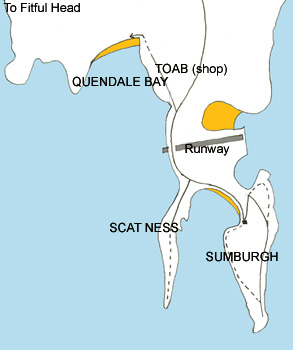 Starting
from the Sumburgh Head hotel walk towards the entrance to Jarlshof, at
the gate turn back south outside the hotel grounds on the edge of the
sea.
Pass through gates or pass walls on the coast side until climbing
towards
the Head. Cross the large field diagonally to reach a gate at the top
left
corner. Explore around lighthouse area for views of birds and whales.
Walk
back down the road to the car park then follow the cliff edge up hill.
The walk here feels rather like a Lake District ridge walk in
miniature.
Continue upwards to the radar installations, where a road can be used
for
easy descent. Back at the hotel gain the beach by the public toilets* .
At the end of the beach go back to the road until the Scat Ness turn
off
and head south for Scat Ness blockhouse. (the route passes over a rocky
section protected by a handrail). Return by the same route and head
north,
crossing the runway under traffic light and airport staff control (it
takes
over 5 minutes to pass through the controlled zone, so don't loiter).
Head
up the side road and buy lunch in Toab if required and then on to
Quendale
Bay beach. It is possible to continue on towards Fitful Head if time
and
energy permit. This walk can of course be split into two or three
shorter
walks.
Starting
from the Sumburgh Head hotel walk towards the entrance to Jarlshof, at
the gate turn back south outside the hotel grounds on the edge of the
sea.
Pass through gates or pass walls on the coast side until climbing
towards
the Head. Cross the large field diagonally to reach a gate at the top
left
corner. Explore around lighthouse area for views of birds and whales.
Walk
back down the road to the car park then follow the cliff edge up hill.
The walk here feels rather like a Lake District ridge walk in
miniature.
Continue upwards to the radar installations, where a road can be used
for
easy descent. Back at the hotel gain the beach by the public toilets* .
At the end of the beach go back to the road until the Scat Ness turn
off
and head south for Scat Ness blockhouse. (the route passes over a rocky
section protected by a handrail). Return by the same route and head
north,
crossing the runway under traffic light and airport staff control (it
takes
over 5 minutes to pass through the controlled zone, so don't loiter).
Head
up the side road and buy lunch in Toab if required and then on to
Quendale
Bay beach. It is possible to continue on towards Fitful Head if time
and
energy permit. This walk can of course be split into two or three
shorter
walks. Photos
*in 2010 official access to the beach is only from the western end, leaving the toilets stranded at the eastern end a road walk away from the picnic site (also western end). Anybody moderately fit could scramble down the three feet of sea-wall at the lowest point outside the toilets, I do not know if this would break any bylaw. The access has been removed to preserve the dune system behind the beach, so on no account climb over that.
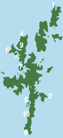
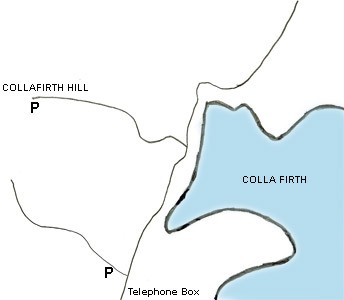 9.Ronas
Hill
9.Ronas
HillThere are two possible starting points for Shetlands highest hill from the A970. The more southerly is a low level start leading onto a 4x4 track that rapidly deteriorates and then disapeears in rather boggy ground below the coll between Colafirth Hill and Mid Field. The more northerly is tarmac to the masts on Collafirth Hill at 233m. Ronas Hill lies due east of Collafield Hill but the intervening ground is more easily covered by walking over Roga Field and Mid Field summits, passing the tarn at Shurgie Scord to its north and then to the final summit. In hill fog I would imagine this is confusing (if safe) ground where a compass would be needed. Beyond the summit it is possible to continue down to the coast to the north west. The summit is "fellfield" and holds interesting dwarf alpine plants. Photos of Ronas Hill
10.St. Ninian's Isle
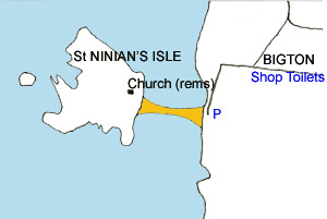 Island
linked to mainline by a fine tombola. Make a circular walk, noting
remains
of celtic chapel where a hoard of silver was dicovered.
Island
linked to mainline by a fine tombola. Make a circular walk, noting
remains
of celtic chapel where a hoard of silver was dicovered.
Photos of St Ninian's Isle
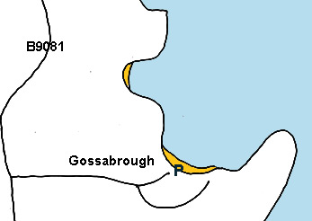
Photos of Gossabrough
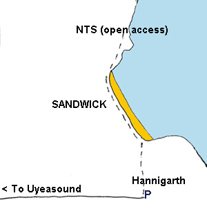
Park at farm and walk across field to interesting Viking remains. Then along beach to NTS land.
Photos of Sandwick
Shetland wildlife guides
Books on Shetland including general guides
Puffin photos
Shetland bird photos
Shetland photos
(maps
not to scale) June 2007